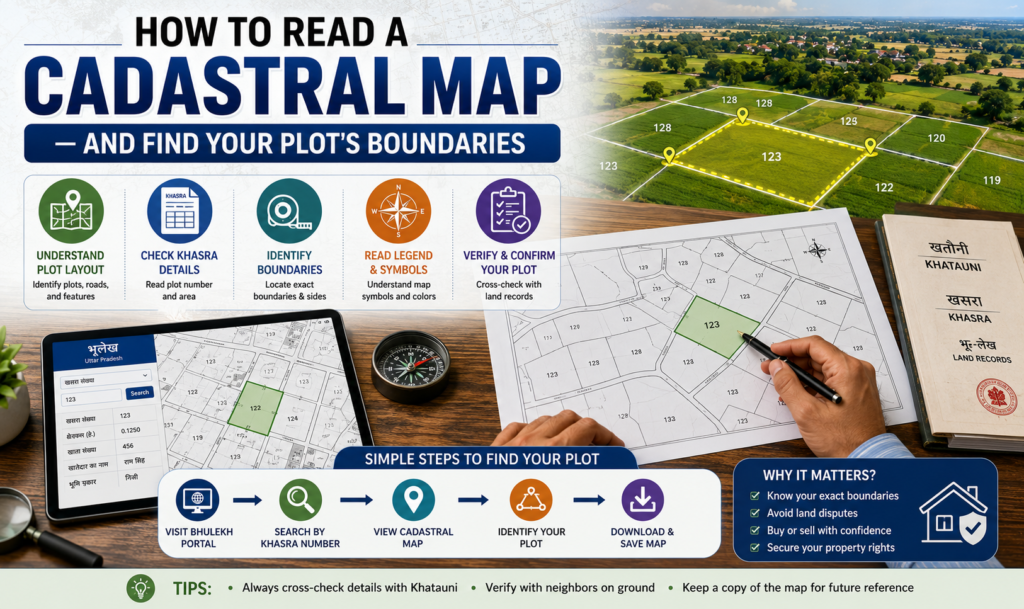
Before you buy a plot, agree to a boundary, or settle a fence dispute, you need to know how to read a cadastral map. A cadastral map is the official government drawing that shows the exact shape, size and boundaries of every land parcel in an area, each tagged with a unique survey or plot number. Once you understand its symbols and numbers, you can locate your plot, verify its extent, and check that what you are buying matches the record.
Cadastral map meaning
The cadastral map meaning is straightforward: it is a large-scale map prepared by the revenue or survey department that records land parcels rather than roads or terrain. Unlike a topographic map (which shows elevation) or a Google satellite view (which shows what is physically on the ground), a cadastral map shows the legal boundaries of ownership.
Each enclosed shape on the map is one parcel of land, identified by a number — called a survey number, khasra number, plot number or subdivision number depending on the state. That number is the key that links the drawing to the textual land record (the Record of Rights) which lists the owner, area and land type.
The parts of a cadastral map
A typical cadastral or village map contains several standard elements:
- Parcel boundaries: the lines enclosing each plot. Solid lines usually mark parcel edges; internal dividing lines mark subdivisions.
- Survey / plot numbers: printed inside each parcel to identify it.
- Area figures: often the extent (in acres–guntas, hectares or square metres) is noted against the number.
- Adjoining features: roads, canals, streams, village boundaries and government land are shown so you can orient the plot.
- North arrow and scale: the scale (for example 1:4000) tells you how map distance converts to real distance; the north arrow fixes orientation.
Reading it is a matter of finding your parcel number, tracing the lines that enclose it, and noting which parcels and features sit on each side.
How to read a cadastral map, step by step
- Get your survey/plot number from your sale deed, the Record of Rights, or the tax receipt.
- Open the relevant village or cadastral map for that revenue village.
- Locate your parcel number printed inside a bounded shape.
- Trace the boundary lines around that number to understand the plot’s shape.
- Identify the abutting parcels — note the numbers of neighbours on the north, south, east and west. These should match the “boundaries” mentioned in your sale deed.
- Use the scale to gauge approximate dimensions, and cross-check the stated area against the textual record.
- Look for subdivisions — a number like 45/2 means plot 45 has been split, and you should confirm which subdivision you own.
Always reconcile three things: the map, the Record of Rights (the textual entry with owner and area) and the physical ground. If any of the three disagree, do not proceed until it is resolved. A verification like an encumbrance certificate confirms the title chain, while the map confirms the physical extent.
Cadastral map online, by state
Most states now publish cadastral maps online, usually through a “Bhu Naksha” or land-records portal run by the revenue department. The exact portal differs by state, but the process is similar: select district → taluk/tehsil → village → enter the survey/plot number to view the parcel highlighted on the map. Our dedicated guide to Bhu Naksha plot maps walks through this in detail.
| State | Where to view the cadastral map |
|---|---|
| Most states / UTs | State “Bhu Naksha” portal (revenue department) |
| Karnataka | Karnataka land-records / Bhoomi RTC and Dishaank |
| Gujarat | AnyROR and the Gujarat Bhu Naksha portal |
| Uttar Pradesh | UP Bhu Naksha (with khatauni records) |
| Andhra Pradesh / Telangana | State land-records portals (e.g. Meebhoomi, Dharani) |
Because links and portal names change, always reach the portal via the state revenue department’s official website rather than a third-party link, and never rely on a screenshot alone for a purchase decision.
How to download a village cadastral map
To get a village cadastral map download, open your state’s Bhu Naksha portal, drill down to the village, and use the “Map Report” or print/download option. Two cautions:
- An online map is usually for reference. For legal use — registration, court, boundary disputes — you need a certified/authenticated copy from the survey or revenue office, sometimes called a “tippan,” “FMB” (Field Measurement Book) sketch, or measurement sketch.
- If the online map and the ground do not match, request a fresh survey (re-survey / demarcation) by the government surveyor, who will physically measure and mark the boundary.
When to get a professional survey
A cadastral map tells you the recorded boundaries, but only a licensed surveyor can mark them precisely on the ground with reference to the FMB. Order a demarcation survey when you buy a plot, before you build a compound wall, or whenever a neighbour disputes a boundary. This small cost prevents expensive litigation later. When you are ready to compare properties with clean, verified records, browse our residential projects.
Frequently Asked Questions
What is a cadastral map in simple terms?
How do I find my plot on a cadastral map?
Can I view a cadastral map online for free?
Is an online cadastral map legally valid for a property purchase?
What should I do if the cadastral map doesn’t match the ground?
This article is for general information only; land-record portals, map formats and procedures vary by state and change over time, so verify current details on the relevant state revenue department’s official portal and engage a licensed surveyor before acting. Godrej Realty Homes is a property listings portal.