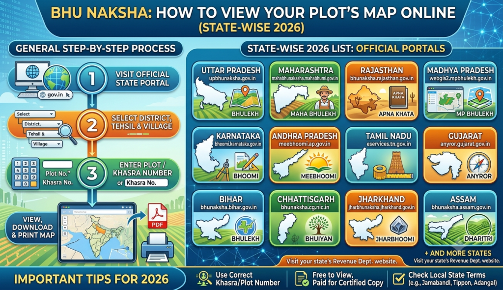
A land record tells you who owns a plot; a land map tells you where it sits and what shape it is. The Bhu Naksha online plot map is India’s state-run cadastral mapping system that lets you view your plot’s boundaries, khasra/survey number and neighbouring parcels on a digital map — an essential check before buying land or resolving a boundary dispute.
What is Bhu Naksha?
Bhu Naksha (literally “land map”) is the online cadastral map service maintained by state revenue and land-records departments. While a Record of Rights or khatauni gives textual ownership details, Bhu Naksha shows the spatial picture: the outline of each plot, its khasra or survey number, and how it connects to adjacent plots. Together they let you match a paper record to a physical piece of ground.
Each state runs its own Bhu Naksha portal because land is a state subject, so there is no single national website. The look and steps are broadly similar, but you must use your specific state’s portal — for example bhunaksha.rajasthan.gov.in in Rajasthan or the equivalent domain for other states.
Why check the Bhu Naksha before buying a plot
Pulling the map is one of the cheapest ways to protect a land purchase. It helps you:
- Confirm the plot’s shape, location and area match what the seller claims.
- Identify the correct khasra/survey number so you buy exactly the parcel you inspected.
- Spot whether a plot has been sub-divided or merged since the last record.
- Check that access roads and neighbouring boundaries are as represented.
Reading the map alongside the ownership record is what makes due diligence meaningful. If the cadastral symbols are unfamiliar, our guide on how to read a cadastral map walks through boundaries, plot numbers and scale.
How to check the Bhu Naksha of a plot
The typical flow across most state portals is the same. To view your Bhu Naksha land map by state:
- Open your state’s official Bhu Naksha portal (search for “Bhu Naksha” with your state name and confirm the .gov.in domain).
- Select your district, tehsil/taluk and village from the drop-down menus.
- The village cadastral map loads. Click your plot on the map, or enter the khasra/survey number to highlight it.
- The plot info panel shows the owner’s name, area and khasra number for the selected parcel.
- Use the Plot Report / Map Report option to generate a printable sheet, then download or print it.
Because the underlying maps are digitised from older survey records, minor mismatches can occur — treat the online map as a strong indicator, not a substitute for a fresh physical survey when large sums are involved.
How to download the Bhu Naksha khasra map
Most portals offer a report you can save. To complete a Bhu Naksha khasra map download:
- After selecting your plot, look for a “Map Report”, “Plot Report” or “Nakal” button.
- The system opens a formatted map/report page for that khasra number.
- Use your browser’s print or the on-page download option to save it as a PDF or print a hard copy.
This downloaded map is useful for your own records and discussions, though for any court or registration purpose you will usually need a certified copy from the revenue office.
Bhu Naksha across states
Terminology and the exact URL vary from state to state, but the concept is identical. A few examples of where the plot map and the parallel land-record portals sit:
| State | Land record portal (text) | Map service |
|---|---|---|
| Rajasthan | Apna Khata / e-Dharti | Bhu Naksha Rajasthan |
| Uttar Pradesh | Bhulekh UP | UP Bhu Naksha |
| Madhya Pradesh | MP Bhulekh | Bhu Naksha MP |
| Karnataka | Bhoomi RTC | Karnataka Dishaank / village maps |
| Andhra Pradesh | Meebhoomi (1B/Adangal, FMB) | Village map / FMB |
If your state does not brand its service “Bhu Naksha”, search for its cadastral or village-map service — the function is the same.
How to verify plot boundaries with Bhu Naksha
To truly verify plot boundaries with Bhu Naksha, don’t stop at the screen:
- Match the khasra/survey number on the map to the number in the sale documents and the ownership record.
- Compare the mapped shape and dimensions with the physical plot and any existing boundary markers.
- Cross-check ownership with the textual record and obtain an encumbrance certificate to confirm the land is free of dues.
- For high-value or disputed parcels, commission a licensed surveyor to physically demarcate boundaries against the cadastral map.
Used this way, Bhu Naksha turns a leap of faith into an informed decision. And when you graduate from land to a built home, the map matters less than the developer’s approvals — you can browse verified residential projects where layouts and titles are already vetted.
Frequently Asked Questions
Is there one national Bhu Naksha website for all states?
What information do I need to view a plot on Bhu Naksha?
Can I download the Bhu Naksha map for free?
Is the Bhu Naksha map legally valid proof of boundaries?
What is the difference between Bhu Naksha and a land record like khatauni?
This article is for general information only and is not legal advice. Bhu Naksha portals, URLs and map data are maintained by individual states and may change or contain errors; always verify current details on your state’s official land-records portal and revenue office before acting. Godrej Realty Homes is a property listings portal.